Esri Malaysia | Home

Main navigation Malaysia

  • Industries
    • Commercial
      • Architecture, engineering and construction
      • Electricity
      • Insurance and banking
      • Oil, gas and renewable energy
      • Plantation
      • Retail
      • Telecommunications
      • Transport and logistics
      • Water
    • Government
      • Central government
      • Citizen engagement
      • Demographics and statistics
      • Emergency management
      • Health and human services
      • Land management
      • Law enforcement
      • Local government
      • Mapping and charting
      • National security
      • Public works
      • Safe communities
      • Smart communities
      • Spatial data infrastructure
      • State government
    • Community
      • Education
      • Esri Young Scholar Award
      • Non-profit
  • Products
    • Capabilities
      • Digital twins
      • Field operations
      • Imagery and remote-sensing
      • Real-time visualisation and analytics
      • Spatial analytics
    • About ArcGIS
      • ArcGIS Online
      • ArcGIS Pro
      • ArcGIS Enterprise
      • ArcGIS Location Platform
      • ArcGIS Developer
      • ArcGIS for Personal Use
      • ArcGIS Online free trial
      • See other Esri products
    • Applications
      • E-government solutions
      • Apps for the Office
      • Field Operations
      • Apps for the Community
      • Geo-Precision Agriculture Solution
      • NV5 Geospatial
    • Data
      • GIS data
      • Open Data
      • Data Interoperability
      • Open Standards
      • Esri’s Open Vision
  • Services and support
    • Professional Services
      • ArcGIS maintenance
      • Project deployment & support
      • Business consultancy
      • Project advisory support
      • Service credits
      • Service Plus Package
      • Enterprise support
      • Embedded engineer
      • Enterprise GIS consulting
      • ArcGIS Enterprise upgrade
      • Disaster Response Program
    • Technical support
      • Esri Support App
      • Support request
    • Training
      • Training calendar
      • Training courses
      • Training FAQs
      • Submit a training enquiry
    • ArcGIS resources
      • A quick-start guide to ArcGIS Pro
      • ArcGIS user types
      • ArcGIS product licensing
  • News and events
    • News
      • Subscribe to news
    • Blog
    • Podcast
      • Esri podcast network
    • Events calendar
      • Webinars
      • Past event presentations
  • About
    • Esri Malaysia
      • Our people
      • Our history
      • Our relationship with Esri
      • Our relationship with Boustead
      • Our partner program
    • GIS technology
      • About Esri
      • Jack Dangermond
      • History of GIS
      • About location analytics
      • Esri Map Gallery
    • Careers
      • Our values
      • Our people
      • Browse jobs
    • Contact us
      • Sales and services (Malaysia)
      • Sales and services (Brunei)
      • Training
      • Support
      • General enquiries
      • Subscribe
Omar Maher

Omar Maher

Director, Artificial Intelligence
Esri Inc., US

Omar Maher is a world-leading specialist in the application of GeoAI and machine learning for utilities, government and multinational companies. As the Director of Artificial Intelligence at Esri, he holds more than a decade of experience in analytics and AI. Previously, Omar co-founded two tech startups that applied machine learning principles to provide smart user recommendations and personalised experiences.
Machine Learning for infrastructure repair inspection efficiency
Machine Learning applications for government and utilities

Presenter: Omar Maher, Esri Inc

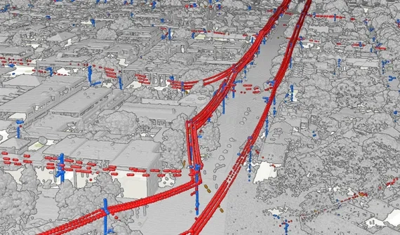
Director of Artificial Intelligence, Omar Maher, shares real-life examples of how machine learning can alert authorities to infrastructure damage, improve inspection efficiency with LiDAR data and track land development against master plans.

Learn more
AI deep neural networks
Blog Replacing 50,000 man hours with AI Discover how one utility implemented a state-of-the-art approach to detecting overhead powerlines with deep neural networks. Learn more
AI and location_blog_CARD
Blog A business guide to AI and location intelligence Business executives, pressed to deliver on strategic goals like market growth and risk mitigation, find important context in combining artificial intelligence with location intelligence technology. Learn more
Esri Malaysia | Home

Footer menu

  • Sitemap
  • Privacy
  • Website Terms and Conditions

© 2026 Esri Malaysia All rights reserved.