Throughout the COVID-19 lockdown, APA's transmission group looked to GIS to fuel a company-wide digital transformation.
APA Group is a world-leading energy infrastructure business, managing approximately $22 billion of Australia’s energy assets, including over 15,425 kilometres of natural gas transmission pipelines, 418 megawatts of gas-fired power generation and 243 kilometres of high voltage electricity transmission. The organisation also manages renewable energy generation, including 149.3 megawatts of solar and 342 megawatts of wind power.
As staff transitioned to remote work, the widespread geographical nature of APA’s assets posed additional operational, maintenance and safety challenges.
With little prior experience, the Systems and Assurance team were able to rapidly design and deploy an ArcGIS-powered GeoHub: a whole-of-organisation geospatial platform creating instant access to data and insights – and for the first time, a consistent cloud-based approach.
The GeoHub is a gamechanger, bringing together company-wide data onto one platform and putting rich maps and apps into the hands of over 1000 users. Everyone who sees it, wants it – from our field crews to our infrastructure planning teams. - Phill King, Manager, Systems and Assurance, APA Group
Within 12 months, over 1000 employees had adopted GeoHub. Staff were no longer bookmarking individual ArcGIS apps and maps – they simply logged into GeoHub for enterprise asset management, third-party data sharing, and a raft of purpose-built web apps.
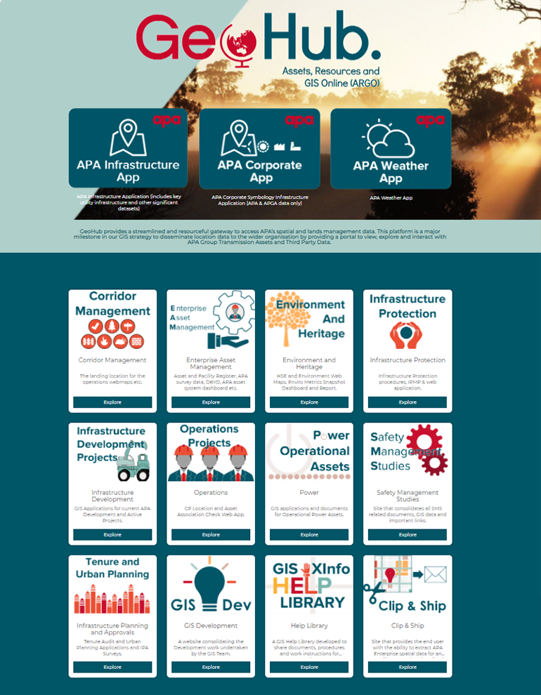
See six ways the GeoHub drives efficiencies and new capabilities across the organisation.
1. Communicating the location of critical assets
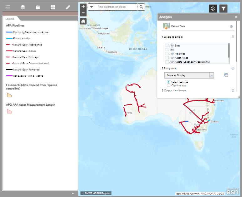
APA receives thousands of requests for pipeline location data each week. To digitise an otherwise cumbersome paper-based process, APA created a ‘clip and ship’ workflow within GeoHub. In Step 1, the employee uploads a signed data agreement into GeoHub, which is saved to a SharePoint location. In Step 2, the employee draws a boundary around the required location within the Esri web app. In Step 3, the spatial data is downloaded and sent to the third party, along with any instructions. The new process replaces hard copy data agreements and streamlines the process from hours to minutes.
2. Enhancing data discoverability
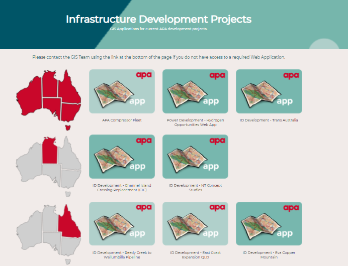
Each team accesses a one-stop shop for all geospatial information. Staff within the infrastructure development team have visibility of all available web apps and can request access to collaborate on interstate projects. The approach maintains data security within the organisation, whilst arming teams with full oversight of ongoing projects – driving greater efficiencies.
3. Integrating existing technology
From within GeoHub, APA syncs record and stakeholder management software such as SharePoint, PowerBI, ECM, and XInfo – breaking down data silos and leveraging the organisation’s existing technology stack. Information from these systems is displayed as a data layer within a web map, providing an instant visual picture of current operations.
4. Driving field crew efficiencies
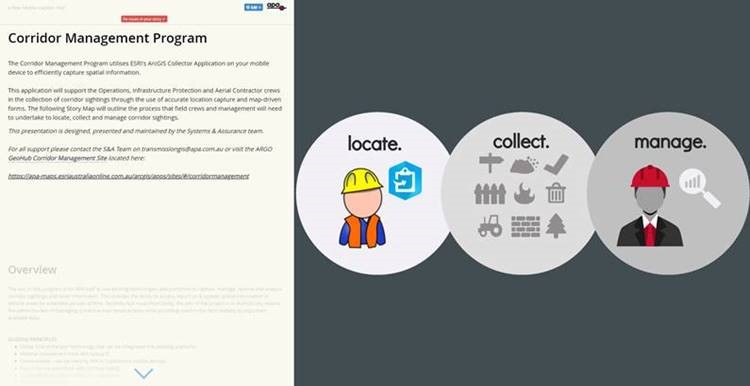
Sitting within GeoHub is the Collector for ArcGIS web app, which enables field crews to efficiently capture sightings and follow up work orders, doing away with email-based workflows. Also linked within the GeoHub is a StoryMap training presentation, teaching field crews how to use the app. The new process saves crews hours emailing photos and offers real-time information on vital infrastructure.
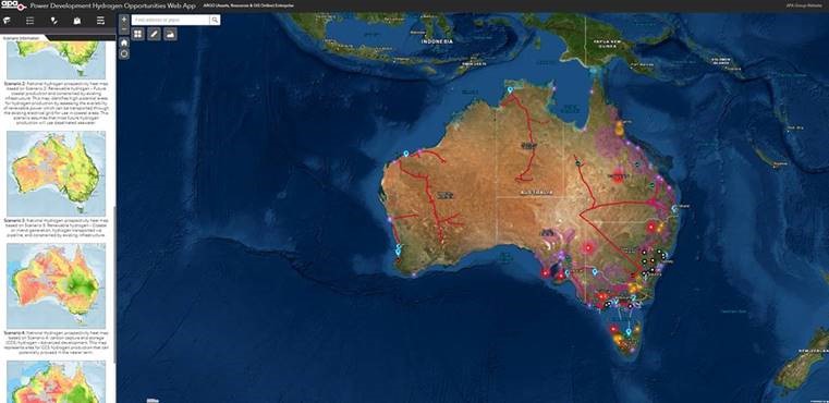
5. Surfacing new opportunities
GeoHub also supports exploration activities with the Hydrogen Opportunities Web App. The app combines scenario information in the left panel – centralising information assets and enabling the group to analyse data and surface new insights faster. It’s a one-stop shop for all Hydrogen documentation, saving time and effort collating key information.
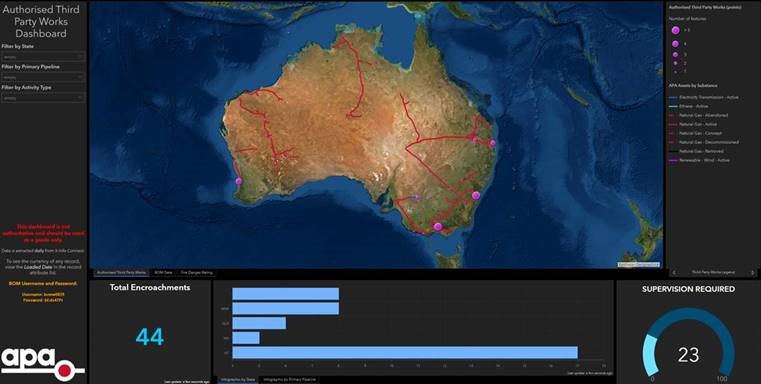
6. Protecting key infrastructure
Replacing spreadsheets, the encroachments web app reports the location of authorised works within the vicinity of the pipeline. The information enables the operations centre and aerial patrol teams to swiftly identify any unauthorised activity that could cause a catastrophic event. The app has driven operational efficiencies by reducing aerial radio communications and unnecessary escalations. The operations centre is now armed with complete oversight of daily pipeline activities – improving safety and peace of mind.
For APA Group, mapping lies at the heart of pipeline management – and situated within the core of location-based technology is geographic information systems (GIS).
The GeoHub has improved collaboration and transparency for all business groups managing APA’s transmission infrastructure – whether in the office, in the field, online or offline. The adoption of GIS into APA’s core business capability is an exemplary demonstration of mass digital transformation, encouraging those with little to no GIS experience to get started today.
If you're looking to get started with advanced location-based analytics and the role it can play in your utility, feel free to connect. You can also visit our gas industry page. Here you'll find case studies, white papers, feature articles and interactive demos - all highlighting the benefits the technology can offer you.