If you ask an electricity utility CIO about the biggest challenge they face within their operations, the answer will typically centre around dated technology.
Utilities often struggle to upgrade their legacy technology: most consider the process too problematic. Replacing legacy systems often incurs far-reaching disruptions - but it doesn’t have to be this way. It’s possible to avoid the upheaval many executives associate with a system overhaul by introducing an advanced location-based analytics solution into your infrastructure.
Four key benefits of a location-based analytics solution
1. Configurable over hardcoded
Rather than taking over your legacy technology, a location-based solution can work with it - strengthening the software you already use by wrapping powerful visualisation capabilities directly over the top. A configurable - rather than hardcoded approach - gives you the flexibility to customise the software to your needs, maximising the return from your existing technology stack.
2. A single source of truth
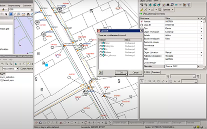
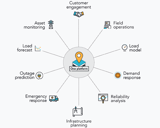
An advanced location-based platform surfaces underutilised data, and integrates it into a seamless, single point of truth. Relevant, ready-to-use map data layers such as asset plans, network status, demand areas, real-time weather, disaster information and more – are all accessible on a central platform at any time, on any device. This has huge implications for the safety of field crews experiencing road closures or flooding - a common operating view enables them to respond more effectively in real-time.
3. Integrate disparate data sources
Make all of your systems compatible: location-based analytics technology is the integrator behind the scenes making sure everything works together seamlessly. You won't need to maintain separate databases to deliver insight to the people who need it. By eliminating data redundancy, you'll discover a more connected, and safer workplace.
4. Incremental innovation over radical changes
If you have a system of record in place, you can use ArcGIS to create an advanced system of engagement on top, democratising data to the wider organisation. This type of change can be implemented gradually, slowly reaching every corner of the business to bring cross-functional teams together.
As utilities transform, the challenges may seem overwhelming - but by exploring advanced location-based capabilities, CIOs can achieve their modernisation goals.
If you're looking to get started with advanced location-based analytics and the role it can play in your utility, please visit our electricity industry page. Here you'll find case studies, white papers, feature articles and interactive demos - all highlighting the benefits the technology can offer you.