Sarawak Land and Survey Department, Sime Darby Plantation, Majlis Bandaraya Johor Bahru among seven to clinch GeoInnovation Awards.
The 2022 GeoInnovation Awards celebrated some of the most successful digital transformation initiatives spanning a range of industries in Malaysia. Among the winners were Sarawak Land and Survey Department, Sime Darby Plantation Research Sdn Bhd, PLANMalaysia@Pulau Pinang, and Pejabat Setiausaha Kerajaan Negeri Pulau Pinang’s (PeGIS) role in developing the Penang Stops Violence mobile app which helps victims get initial assistance from First Support Point Officers.

"We have seen how geospatial technology underpins the digital transformation strategies of some of the country’s most progressive organisations. We are humbled and privileged to see the ingenuity of how these organisations address real-world challenges especially when there were no traditional solutions," said CS Tan, Chief Executive Officer, Esri Malaysia.
Regardless of the field or industry that it has been applied to, Tan said, the technology's expansion and development has helped civic leaders make data-driven decisions about complex urban problems while supporting commercial organisations in addressing inefficiencies in their operations.
Sime Darby Plantation Research Sdn Bhd – is tasked with developing, applying and transferring relevant knowledge, research findings and technologies to improve plantation yields, milling processes and customise downstream products. Its winning project: Spatial Data Management & Rapid Analytics or SMART is an interconnected web and mobile-based geospatial platform developed by the Precision Agriculture Unit; the geospatial research arm of Sime Darby Plantation Research Sdn Bhd. SMART enables Sime Darby Plantations to visualize data like never before.
SMART creates a geospatial data ecosystem in Sime Darby Plantation, connecting more than 330 multi-disciplinary users across departments resulting in around a 30% - 50% increase in work efficiency. With location intelligence, SMART enables users to see the bigger picture, and make better decisions.
The Land and Survey Department, Sarawak, Malaysia has already received accolades recognising its Electronic Land and Survey Information System (eLASIS) project and its Mobile LASIS project (an extension of eLASIS). eLASIS was created to establish a one-stop virtual office to digitally transform the department's service delivery system with the mission of ‘bringing the office to every doorstep’.
Having an area of 12.4 million hectares of land mass with a scattered population of 2.9 million in 12 divisions, 45 districts and 24 sub-districts, eLASIS provides vital land information, geographic location and cadastral boundaries, integrated with GPS and imagery base-map, for “fast, accurate and reliable” services through a safe and easy to use platform that is accessible anywhere, anytime.
The Department says eLASIS and Mobile LASIS is a continuous transformation to its service delivery system to cater for the customer’s needs and has proven to be efficient and effective during the MCO when the public is affected by the COVID-19 pandemic. Online transactions show a rise of 42% to 257,421 and consequently online revenue collection increased by 147% to RM7,823,934 in 2021.
The third winning organisation was PLANMalaysia@Pulau Pinang which implements the main duties of urban and rural planning including the preparation of a long-term master plan. Its online mapping application MY KAMPUNG allows PLANMalaysi@Pulau Pinang to share data and collaborate more effectively with government agencies and other stakeholders. Access to updated information on villages across the region assists in formulating planning, development, monitoring, and conservation of village level policies.
PeGIS' mobile application project – Penang Stops Violence – is part of the state government's 'Penang Goes Orange' campaign which aims to halt violence against women. PeGIS collaborated with Penang Women's Development Corporation (PWDC) on the mobile application to help friends, neighbours or victims of domestic violence obtain more channels for assistance, lodge complaints and receive help from First Support Point Officers.
Penang Stops Violence allows users to contact the officer directly through telephone or go to the location of the First Support Point displayed on the app. The award-winning app combines textual and geospatial data and works to minimise injuries and loss of life.
The next winner, Majlis Bandaraya Iskandar Puteri (MBIP), is the second youngest City Council in Malaysia which developed the Sistem Pengurusan Aduan Awam (SISPAA) system to resolve citizen complaints. The Dashboard SISPAA was developed with the research team under The Global Future Cities Programme, funded by the UK Government's Prosperity Fund.
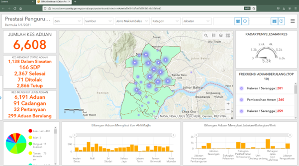
SISPAA allows for complaint coordinators in each department with MBIP to inspect, reply, and resolve issues. Seventeen heads of departments can access the performance metrics of their team with filter functions and monitor the active complaints. Remedial works are easily planned and deployed as teams can access complaints according to location and work is monitored by the department heads, the Mayor and Secretary. Within the first month of its implementation, there was a 2% increase in resolution on complaints within 14 days, compared to the previous month.
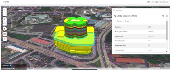
The Majlis Bandaraya Johor Bahru (MBJB) Portal GeoJB, the data platform that integrates spatial and non-spatial data from various internal MBJB systems, also received an award this year. The portal was designed to manage the city in a smart and sustainable way to realise the dream to achieve an ‘Intelligent Johor’ and inspire and contribute to Malaysia's development while attaining the nation's goals to become a more resilient and liveable nation.
While Portal GeoJB is most popular for Local Plan zoning and development guidelines checks, it is also used to check and verify precinct, district, state constituency, and other boundaries, as well as development approval status. There are other functions available on the portal including the assessment and licensing dashboard, which has been used as an urban observatory for Johor Bahru City towards Greater Johor Bahru.
The Majlis Perbandaran Kulim (MPKK) in Kedah also received an award for the implementation of a data central system through the development of Kulim Integrated Database System (KIDS). The local authority has various data in tabular formats consisting of both structured and unstructured data that can be manipulated and defined by the new database system for specific uses. The system allowed for updated information, and integrated departmental data input. Having the system in order allows for better decision-making, policy shaping and monitoring, as there is updated data and information is better maintained through it.
Some of the KIDS modules such as Planning Control, Zoning Checking, Valuation Updates, Drainage System and OSC Application also favour the execution of MPKK’s Express Construction Permit (E10) initiative which efficaciously facilitates developments, construction work and productions without any delay. This dynamically leads to a higher investor engagement resulting a bigger and more positive impact on the local economy. Between 2016 - 2022, Kulim managed to attract more than RM52 billion investment both locally and internationally. At the same time offered more than 10,000 high-skilled job opportunities for Malaysians.
"Esri Malaysia is proud to watch the impact it has delivered in empowering and enabling the decision makers make a positive change to businesses and society and we hope this inspires more people to journey towards digitalisation," Tan said.
For the latest updates on news, products and events from Esri Malaysia, register now.