Cutting-edge Malaysian GIS technology applications, which provide a comprehensive overview to manage critical services, have been recognised at the Esri User Conference in San Diego, USA, today.
Among Malaysia’s most progressive organisations – Alam Flora Sdn. Bhd., Dewan Bandaraya Kuala Lumpur and Tenaga Nasional Berhad – received coveted Special Achievement in GIS (SAG) Awards, at the conference attended by more than 100,000 delegates from around the world.
The smart mapping systems recognised by Esri demonstrate how the visualisation of data amplifies business impact and synchronises workflows across departments.
Alam Flora
A leading environmental management company in Malaysia, Alam Flora, collects more than 4000 tonnes of waste per day, with the bulk of the waste transport carried out by 1000 specialist trucks. These waste disposal units provide service to residents across a vast 36,424 square kilometre area, underpinned with real-time, location analytics.
A subsidiary of Malakoff Corporation Berhad, the country’s leading independent power producer, Alam Flora continues to streamline workflows with the support of geospatial technology. One of the largest concession holders of Malaysia’s national solid waste management and public cleansing project has digitised its reporting methods, interpreting data from a comprehensive 360-degree view of works undertaken and completed, including fleet tracking. This has greatly reduced the need for staff to visit sites and manually report, providing a more efficient overview of activities.
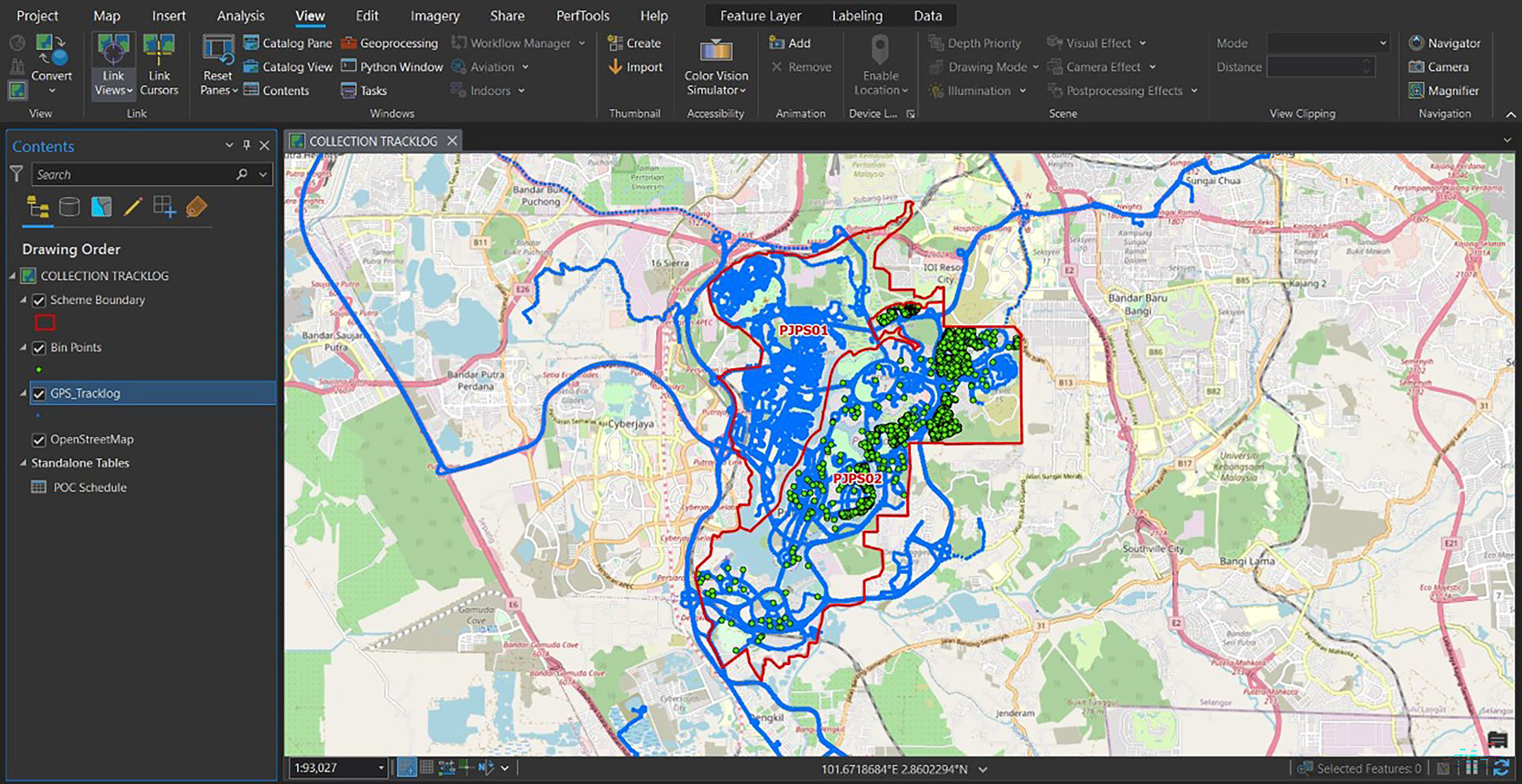
“As a result of implementing the geospatial app with IOT sensors, our performance at collection points has increased from 76% to 95% over a 10-month period. This represents an almost 20% improvement in meeting waste disposal targets. To achieve this, more than 100 staff across Alam Flora share geospatial data for planning and decision-making. On top of cleaner public spaces, Alam Flora has substantially reduced the penalties for missing waste collection – a challenge of the previous manual system,” said Kamal Hijjal Kassim, Head of Digitalisation, Alam Flora Sdn. Bhd.
Dewan Bandaraya Kuala Lumpur (DBKL)
Tasked with keeping a bustling city of more than 8.8 million people moving, Dewan Bandaraya Kuala Lumpur (DBKL) scaled existing capabilities to address common operational challenges with innovative thinking. Before undergoing any maintenance works or planning, DBKL was required to consult with each of the city’s utility agencies to gain access to location analytics of pipelines or underground energy grids. Streamlining access to the data gives DBKL a fuller picture of operations, for example, when installing electrical cables or responding to natural disasters.
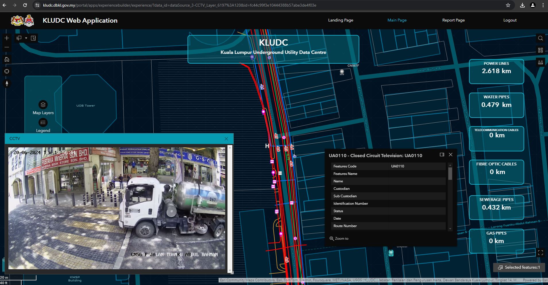
“Our capital city is becoming a smart city. To meet the needs of residents, visitors, businesses and commuters, we need upgraded or new infrastructure. We use location analytics, to know what’s under each road before construction or repair work starts. Whether it’s laying a new cable, building a pavement or new road or managing a sinkhole incident, our GIS system gives us precise data to make prompt decisions and work efficiently,” said Gs. Sr. Zulkifly Rizal Isfahani, Head of Underground Utility Mapping & KLUDC Unit, Jabatan Penilaian & Pengurusan Harta, DBKL.
Tenaga Nasional Berhad (TNB)
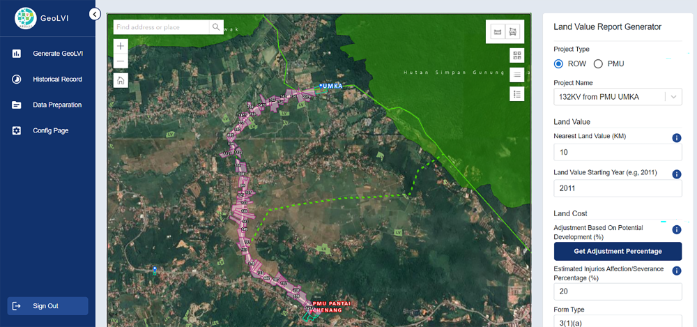
TNB is responsible for generating, transmitting and distributing electricity to homes and businesses. The green energy transition requires upgrades to the nation’s power grid. As part of the upgrade, TNB acquires new land parcels and maps out new transmission line routes and energy grid substation locations. To meet energy demand and manage land asset valuations, TNB has also developed a land resumption system, to support the building of future powerlines.
Previously, land value data was manually processed, which led to a disparity in costing estimates in budgets and land acquisition.
“The opportunity for disparity is now greatly diminished with the development of a centralised data hub. Now, staff have the capability to map and analyse land value information regarding grid infrastructure siting proposals, providing business units with the flexibility to optimise their investments, most notably those involved in transmission line route and substation site selection and land acquisition,” said Abd Rahim bin Mohd Yusof, Head of Grid Strategy representing TNB.
Esri Malaysia Chief Executive Officer Mr CS Tan said, “The awards presented to DBKL, TNB and Alam Flora represent Malaysian ingenuity on a global scale. Their success is testament to the fact that our geospatial community is at the cutting-edge of developing a more sustainable, efficient and smart future.”
If you would like more details or have any questions, please contact the media team.