Tenaga Nasional Berhad (TNB) is strengthening the national grid through major infrastructure investments. These efforts aim to ensure reliable energy delivery, support Malaysia’s zero-carbon goal by 2050, and integrate renewable energy to enable cross-border interconnections under the ASEAN Power Grid initiative. To successfully implement these initiatives, TNB requires a comprehensive understanding of land availability and projected development costs.
Tenaga Nasional Berhad (TNB) is Malaysia’s largest electricity utility and the primary generator, transmitter, and power distributor across Peninsular Malaysia, Sabah, and Labuan. The company serves about 10.6 million customers as of December 2022. Its generation portfolio (in Malaysia) totals roughly 2,896 MW from renewable sources, including large hydro, and an additional 993 MW internationally. TNB’s grid covers high-voltage networks (132 kV, 275 kV, 500 kV) and interconnections with neighboring systems. By the end of 2021, its transmission network spanned over 28,339 circuit-kilometers.
Challenge
TNB Grid faced a critical challenge: planning new transmission routes and land use more effectively while balancing cost, environmental impact, and stakeholder needs. Traditional methods often lacked the precision and speed required for modern infrastructure projects.
TNB’s Grid Division underwent a significant restructuring in 2017, establishing the Grid Strategy Department and its Land Planning Unit to support future grid infrastructure planning. The Land Planning Unit plays a key role in evaluating land suitability, estimating land acquisition costs, and ensuring the strategic and sustainable expansion of the transmission network. However, as project demands grew, the unit faced challenges in accurately estimating land acquisition costs due to limited access to comprehensive data, primarily relying on non-spatial information. These limitations hindered the unit’s ability to identify spatial trends and performing meaningful data correlations. Without adequate analytical tools for land cost estimation, it became challenging to optimise land acquisition budgets, leading to significant discrepancies between planned and actual expenditures. These discrepancies were largely driven by the inability to factor in key variables such as zoning, infrastructure development, and dynamic market conditions.
Solution
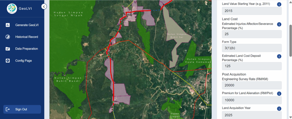
Improving the accuracy and efficiency of land acquisition cost estimation became critical to support the growing demand for infrastructure development.In response, TNB developed a smart geospatial application using ArcGIS, known as Geo Land Value Information (GeoLVI), partnering with Esri Malaysia throughout the project. Esri Malaysia provided end-to-end support, including data modelling, implementation, and configuration. This solution enhances budget forecasting and planning by equipping TNB staff with access to enriched data and spatial analysis capabilities. GeoLVI automates the estimation of land costs and facilitates land value analysis for the Grid Division. It stores land transaction data with geolocation, enabling geospatial and statistical analysis. These insights are then used as a reliable reference to estimate land costs for future infrastructure projects, helping to align planning with actual market conditions.
Result
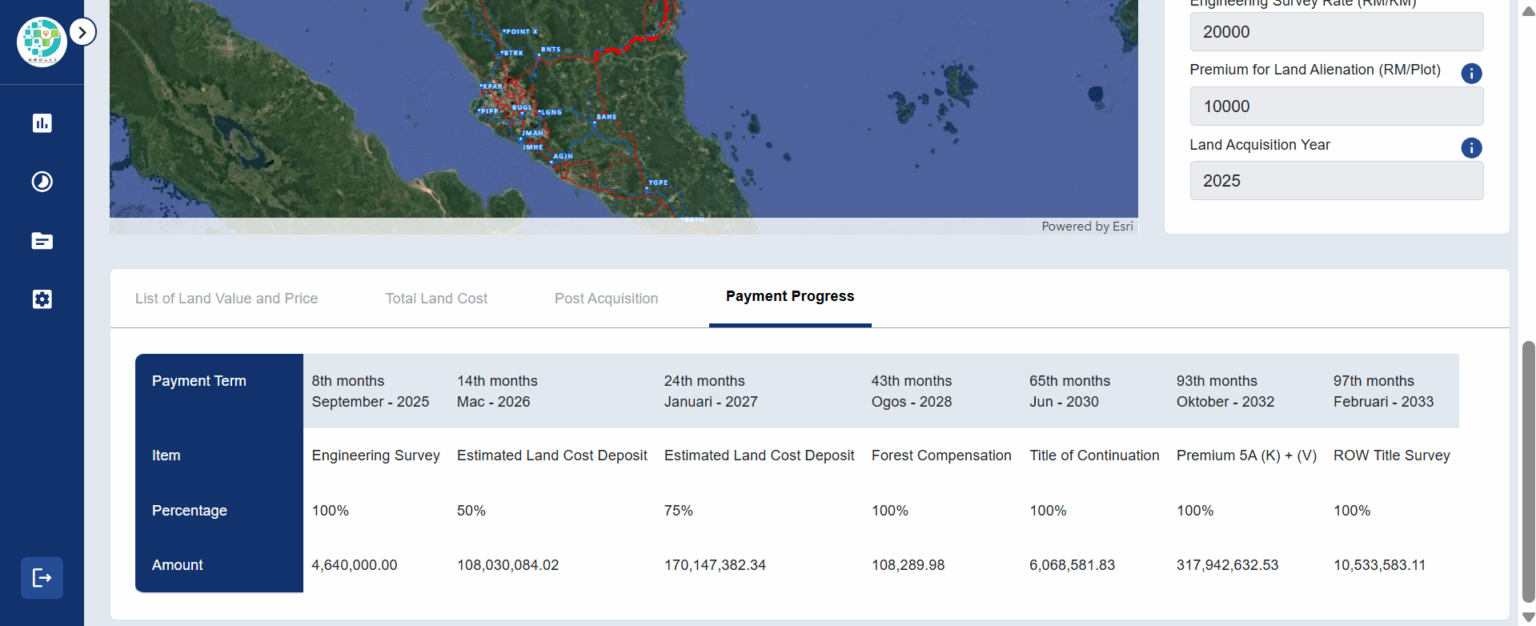
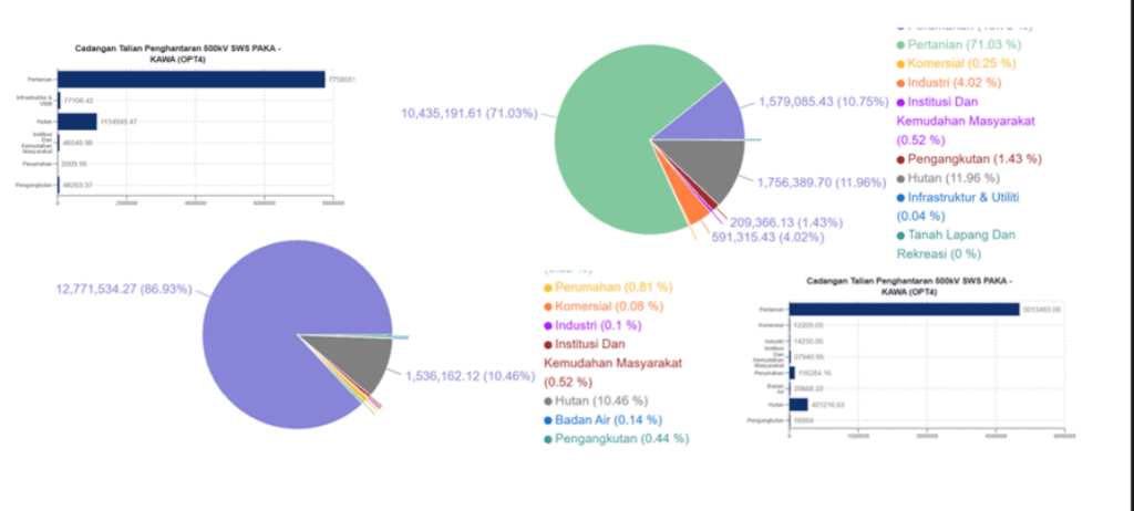
TNB uses Esri’s ArcGIS Pro and ArcGIS Enterprise to digitise land data, perform spatial analysis, and create smart maps that are available across TNB. The web-based solution is designed to help TNB assess the value of each land parcel along the Right of Way (ROW). It enables TNB to calculate costs, predict expenses, and forecast taxes using input data such as current land use, future zoning, and high-risk areas. The valuation data will also support TNB in planning future improvements for constructing and aligning new ROWs.
Benefits
TNB gained substantial business benefits from implementing the GeoLVI application:
- Reduced land cost estimation processing time from months to hours or minutes.
- Improved overall operational efficiency.
- Enabled faster decision-making.
- Accelerated project approvals for future grid infrastructure projects.
By utilising actual land transaction values, the application enhanced the accuracy of land cost estimations, ensuring that financial projections were based on actual land transaction records. Thus, the web-based application enhanced the accuracy of cost estimation. In addition, GeoLVI centralised land value data, allowing for more consistent and efficient land information management across the organization. This streamlined data storage, access, and updates make tracking land values in real-time easier.
“As the main driver for the successful energy transition transformation journey, we are committed to doing the right things from the beginning and empowering others to do things right.”
Abdul Rahim B Mohd Yusof, Head of Grid Strategy Department, TNB
The system’s comparable analysis feature allowed users to compare the cost of affected land with similar properties. This functionality provided context-driven insights, improving the reliability of land cost estimates by considering land value samples from properties near the subject property. GeoLVI also facilitates historical price trend analysis, enabling the Grid Division to analyse past land value trends and forecast future price fluctuations. This insight supported long-term planning and more informed decision-making.
One of the issues TNB faced was the difference between what the company planned to spend on land and the final price of land they had to pay. The more accurate land cost estimations reduced the variance between the planned budget and actual land acquisition costs. This helped align project budgets with real costs, minimizing discrepancies and ensuring more precise financial forecasting.
GeoLVI created an enterprise system with broad access, reduced the process time and costs, and supported the infrastructure expansion goals of TNB.
Reach out to our specialists to see how GIS can help modernise, optimise, and accelerate infrastructure and utilities projects in Malaysia.